
Won’t the blue line fall off of the turtle’s back?
Not if your fast.
What about my fast?
If you bring your fast with you then you don’t fall off the slow turtle.
If you’re lucky you get caught in the Circumfence
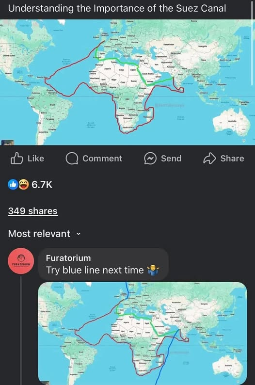
I have no idea about shipping routes or ships in general. But why the detour to Puerto Rico? Why that stupid ass tilt to the north when going to Africa? Why go around the eastern coast of Madagascar instead of along the western coast? Does this shit even make sense?!
I would suppose that it’s showing an actual trade route that was frequently taken. First stop Caribbean to pick up sugar or something, salt in West Africa, Eastern Coast of Madagascar perhaps has more developed trade than on the west coast. Not the shortest route being depicted here but perhaps the highest value trade route.
They wouldn’t unless they were picking up trade. All the maps showing the cape route show them sticking to the coast of Africa
I think the detour to Caribbean does make sense if you’re on a sailing ship. You want the most downwind route, not necessarily the shortest route. I think that detour skirts around the typical Azores high, which is associated with very low wind speeds.
I don’t know about the east coast of Madagascar. But one theory is it might be like Florida: Between Florida and the Bahamas, there’s a quite strong northbound current, so southbound sailing vessels will swing way out east of the Bahamas.
Between Florida and the Bahamas,
Isn’t that the Bermuda’s triangle? Scary stuff happens there, let me tell you.
deleted by creator
How does the green line explain the red line’s detour to the Caribbean or the loop around Sri Lanka?
Earth is neither flat nor round, it’s a torus
Tubular earth
Final Fantasy players be like
Who go all the way to south America and not just around the top of Africa with the red line?
To get limes so you don’t get scurvy.
There’s … ummmm… reasons… they went from Africa to the plantations in the Caribbean before heading home.

AROUND THE HORN LIKE GOD INTENDED.
This isn’t snake lmao
Fellow tubular earth enjoyer


