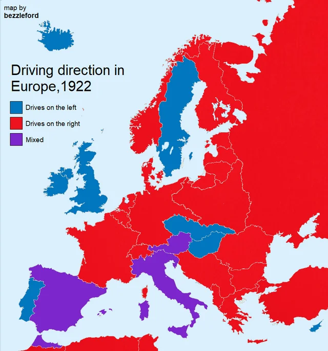
How does “mixed” work? Variations at the local level? People just ignoring the rules and doing what they like? Or is this a joke that I’m too American to get?
Also, I can definitely tell those colors apart for left and mixed super easy, I totally know which ones are which, just don’t ask me to prove it.
I assume the traffic just moved slow enough at that point in time that the rule was “make way” when you saw another vehicle rather than “always stick to this particular side”.
Again, this is just an educated guess and have absolutely nothing to back up my assumptions.
I think the question is asking for an explanation of how that is possible that some areas are right and some are left within the same country. Does the local government decide (city, state, etc), or is it something else, and why.
Additionally, they seem to be partially color blind, since they can’t differentiate the purple from blue.
Edit:
Copying my other comment here, based on some light Internet research which may or may not be accurate.


How does “mixed” work? Variations at the local level? People just ignoring the rules and doing what they like? Or is this a joke that I’m too American to get?
Also, I can definitely tell those colors apart for left and mixed super easy, I totally know which ones are which, just don’t ask me to prove it.
Comments like these remind me that so many maps are super unfriendly to the color blind, which has to be annoying to so many people
Edit:
Didn’t realize this was specifically in 1922, so it looks like it is probably due to a combination of war/control and legal changes.
Austria was apparently split based on which part of the country was controlled by Napoleon, and this lasted for quite awhile, though a few sources cite different lengths of time for the mixed driving laws. I wanted to use a local source here but it was paywalled.
Also, apparently Italy and Spain (and Canada?) changed from left side to right side drive in the 1920s, so this probably reflects that change in Europe.
This is a 1922 map though, not current
Yeah i totally missed that, edited my edits. Thanks!
I assume the traffic just moved slow enough at that point in time that the rule was “make way” when you saw another vehicle rather than “always stick to this particular side”.
Again, this is just an educated guess and have absolutely nothing to back up my assumptions.
If you don’t know stuff about a topic… how can a guess be “educated”?
“I am educated and this is my guess.”
“OK, I may only be educated in underwater basket weaving, but still…”
Now I want to be educated in underwater basket weaving!
Sorry, I’ll just present my assumptions as fact next time.
I think the point is that it’s just a guess, not an educated guess.
Italy, Spain and Austria are in purple. “Mixed” means that there was a mix of left and right in various regions of the country.
I think the question is asking for an explanation of how that is possible that some areas are right and some are left within the same country. Does the local government decide (city, state, etc), or is it something else, and why.
Additionally, they seem to be partially color blind, since they can’t differentiate the purple from blue.
Edit: Copying my other comment here, based on some light Internet research which may or may not be accurate.
Austria was apparently split based on which part of the country was controlled by Napoleon, and this lasted for quite awhile, though a few sources cite different lengths of time for the mixed driving laws. I wanted to use a local source here but it was paywalled.
Also, apparently Italy and Spain (and Canada?) changed from left side to right side drive in the 1920s, so this probably reflects that change in Europe.